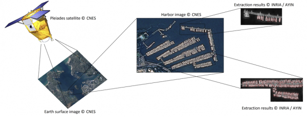
Do you know that over 50 satellites are launched every year to orbit the Earth? Have you ever wondered what the purpose of those satellites is? Here is one of them!
With the launch of the first satellite, a new way of gathering information about the Earth’s surface has emerged. Highly sophisticated cameras are built on the satellites to obtain very high resolution images. Satellites nowadays provide images at a resolution of 0.3 meters! It means that you can even identify your own scooter! Huge amounts of data are collected every day using these cameras. Still, all this data is meaningless, unless the images are further analyzed and understood.
A first step in understanding what is represented in an image is to identify the objects which it contains. We will focus here on identifying boats in harbor images. Boat extraction in harbors is a preliminary step in obtaining more complex information from images such as traffic flow within the harbor, unusual events, etc.
When you look at a satellite image of a harbor, you can visually detect the boats based on their characteristics such as the fact that they are usually in water, their white color or their elliptical shape. All these characteristics make it easy for us humans to correctly identify the boats and discriminate them from other objects such as cars, buildings or trees. Nevertheless, humans know the concept of a boat, while computers don’t. Tell a computer to identify a boat and it won’t know what you’re talking about.
In order to use a computer to detect boats, one must first identify all the characteristics that make a boat unique. Some of them were mentioned before, can you think of others? Once you write down a list of all such characteristics, you then have to define them in a mathematical manner. Put all these mathematical characteristics together and you have developed a mathematical model for boats in harbors. Keep in mind that you must model both the boat itself, as well as the relationships between the boats. One example of a relationship between two boats is the fact that they are usually not allowed to overlap. Note that if the final result is not satisfying, it probably means that the model is poor and you should try to improve it!
The last step is to integrate this model into a framework that allows you to extract only those objects that fit the model and neglect all others. Probabilities play an important role in this step. The computer will search for a configuration of objects until it finds the one that best describes the real data in the image. In the best case scenario you’ll end up with a configuration that incorporates all the boats in the harbor and can then move on to doing more interesting stuff with it!
Paula Crăciun and Josiane Zerubia
INRIA Sophia-Antipolis Méditerranée
BP 93, 2004 Route des Lucioles
06902 Sophia-Antipolis Cedex – France
URL: https://team.inria.fr/ayin/
